 Although this wasn’t my first trip, it was the most recent, so we are starting off our journey here. My good friend Jared and I recently headed down near Green River, Utah to some sites along the San Rafael Swell.
We had heard you can find these geode filled mud balls anywhere from just North of Goblin Valley all the way up to I70 along the swell. And, of course, to pick up any petrified wood, agate, or anything else would just be an added bonus!
After walking around for quite some time, we had come up mostly empty handed. Some fossilized coral, a moqui ball, and an old rusty flask (but no drunken prospector!) was all we had to show for ourselves. Not to mention I had a total of three heart attacks–
 1. Walked right up on huge snake just chilling in the sun (I couldn’t even begin to tell you what kind it was as I was a little preoccupied with not pooping in my pants).
2. Observed two spiders that had apparently either fought or mated to the death (their two giant black bodies were intertwined and long since expired).
3. Had a jack rabbit who waited until I was about two feet away before freaking out and jumping around making quite a show (I was already on edge with my knife at the ready waiting for another snake or the ghost of the prospector).
 After driving along a few more miles, Jared (or Big J as we like to call him) about jumped out of the car before I had the chance to stop. He had seen a flash of red alongside the road and demanded we stop right then and there.
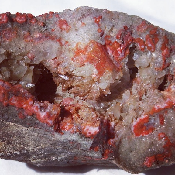
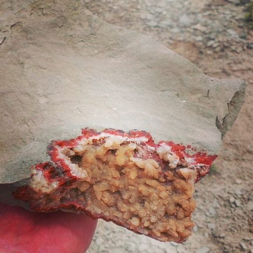
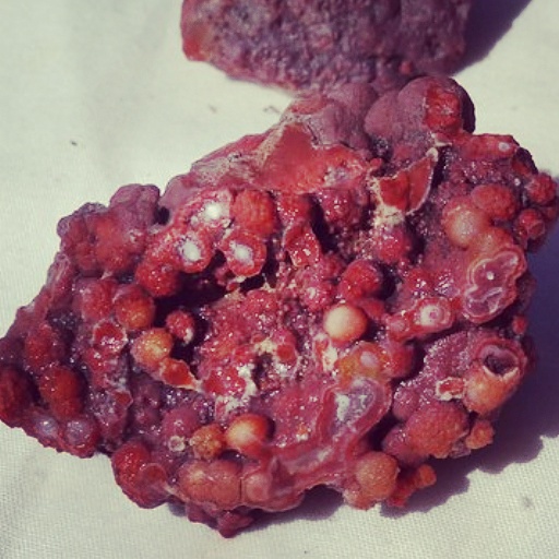
Much to our delight, we (And by we I mean Big J) found the cash crop. A scattered shale outcropping was intermingled with numerous pieces of jasper, agate, calcite, and celestite. Cuts and scattered pieces of geodes contained super brilliant colors. We filled up a few buckets and dug around for another hour or so in an attempt to gather some whole geodes to cut back at home. It was an agate-filled mudball geode wonderland!
 For any interested, we jotted down the GPS coordinates for this particular site (don’t worry…although you could tell that others had been there before, we have only scratched the surface).
Here they are: 38°51.5′N and 110°25.6′W
Directions to Hatt Ranch, Greasewood Draw, and the Squeeze:
From the intersection of 800 North and I-15 in Orem, Utah
1. Drive South on I-15 for 13.5 miles to Spanish Fork exit 258. Stay left onto Highway 6
2. Drive Southeast on Highway 6 for 127 miles until you hit I-70
3. Go left (West) on I-70 for 8.3 miles to exit 149 and take a left on UT-24
4. Drive 3.8 miles to a turn off to the right toward Hatt’s ranch and take this road due West
5. Go straight West for another 4.1 miles to an intersection
6. Take a left at the intersection and drive for 600 feet to the destination
7. On this one I had to use Google Earth so I hope this is the correct outcropping. If not, feel free to explore around the area because you will find great stuff all around you
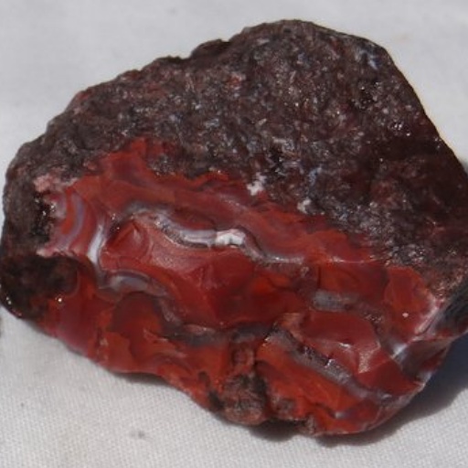
Polished Hatt Ranch agate
https://ibb.co/7RgjCXv
Thanks man! beautiful place and loaded up with agate
amazing
Polished Hatt Ranch agate
https://ibb.co/7RgjCXv
Just came from site. Coordinates work, and I think the pin too but my maps always loses signal, and after 2 iffy sand drifts I parked my car (2wd car, 4wd higher clearance will be fine) and hoofed it the last 2 miles. Coordinates are mostly smaller bits, not much larger than a golf ball. If you drop down on the right, about where the side-track of the coordinates curves there’s a tiny wash with bigger pieces, baseball or so. But the real spot is half mile before coordinates. On the road there’s a lone reddish sandstone tower where the road crosses the river–big rocks, 15 feet across or more. The tan cliffs on the left have patches of what looks like dark red sand at the bottom. They are gravel beds of jasper. Closer to the cliffs it’s bigger as it weathers. I got more colors and bigger grapes here. Someone into digging might do well carefully excavating the cliffs, but there is a lot of overburden.
Went to the floy location and it was a complete let down. There was some agate, but very poor quality (not even worth keeping). Yellow cat flats is my go to for agate. Always good stuff there and if you luck out you may find little chips of redwood.
So what are the red rocks in your picture
Hi! most of the red you’ll see from this area is jasper/agate. It’s fairly hard and most of the time takes a decent polish.
Will be in the Moab next week. Plan on spending a day or so in the Yellow Cat area. Was wondering if you had any specific directions or gps coordinates for petrified wood in that area. Plan to take a look at you geodes in the Hatt ranch area, either on the way there or the way back.
Going to Moab area next week, plan to spend a day or so in the Yellow Cat Flat area. Was wondering if you had any gps coordinates or specific instructions for petrified wood in that area.
We may well lbe going to Green River over President’s Day. I just want to clarify, the directions are to the geode site, not just the GPS? By the way, really erupting your blog!
Enjoying lol
Erupting with joy maybe? ha ha ha. Good question. This is one of the first places we went before I had the idea for this site. Back then, I thought I would just put the GPS coordinates for each of these locations. Since then, however, I starting using Google Earth on a lot of these and with my directions I can get pretty close to the exact location just going off landmarks I remember. I would use both just in case though 🙂 I love this area. I’m not sure if you guys have time, but I would highly recommend shooting out to the Yellow Cat/Poison Strip area or maybe over by the Klondike Bluffs/Little Valley area. Great stuff there and not too far away. Also just South of the Floy exit there is some good pidgeon blood agate. I’m not sure what you guys like collecting and I know some of these areas are popular, but there is still plenty of material. Too many great locations and I’m not even close to putting them all on the blog ha ha ha!
I collected in the floy area last October with my local rock club. You could spend weeks there and just scratch the surface. I am definitely interested in the Yellow Cat/Poison Strip area, but I want a chance to really explore it, which is not this trip. We’ll probably head down closer to Goblin Valley and Capitol Reef.
Oh and for a few more pics to get you excited for your trip (sorry, I haven’t really started my photo gallery on the site yet; hopefully soon!) I did create a thread about this location over on a proboards forum: http://andy321.proboards.com/thread/65770/san-rafael-swell-image-heavy
Checked the pics out and pmd you on the form.
Thanks for the info concerning the hatt ranch geods! My wife and I, and dog are planning a trip the middle of Feb. Will this be a good time to go? Again I really enjoyed your blog . I will let you know how we did, along with any new locations we might find.
.
Hi Rick! Glad to hear that 🙂 I look forward to hear how it goes for you guys. I would say February would be perfect for this location as long as you avoid any snow. It seems like the Green River/Moab area has been unusually cold this year. I had a trip planned over the New Years break to go down around this area again, but checked a few of the UDOT traffic cameras along I-70 beforehand and saw snow on the ground. Bummer! We ended up going to to the Cadys Mountains in Southern California instead. I totally wish you the best if you do end up going!