Sunstone Knoll

In the vastness between the towns of Delta and Milford lies a small knoll just East of Highway 257. This location is a must to include for any rockhounding trips near either town simply because it is just off the highway and collecting is relatively easy. So far I’ve been several times and it has always been worth the sidetrip.

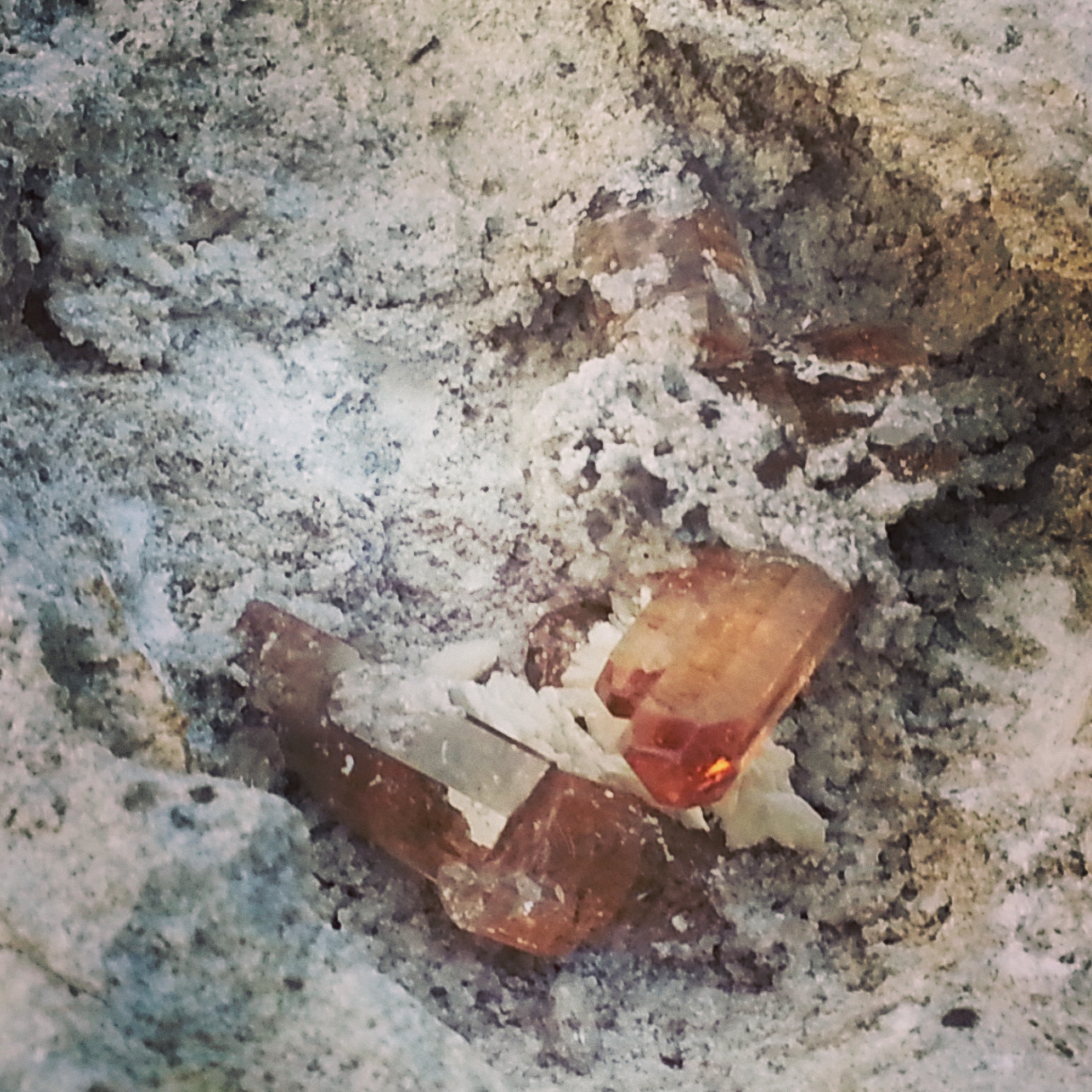
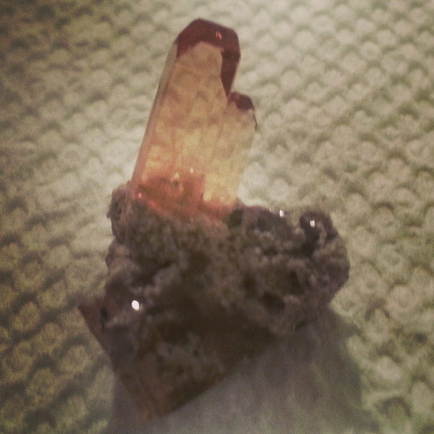
To my knowledge, most sunstones usually come from the state of Oregon or from Norway, but this little spot in Utah has some really nice yellowish specimens. People you ask will provide different answers as to just where on the knoll is the best place to collect, but most of the activity I have seen is on the Southern tip where there is a little bit of a peak on the Eastern side. My greatest success hasn’t necessarily been on the peak itself where you can see people have been constantly chipping away, but instead on the steep slopes around the peak where the stones will gather amongst the brush. I’ve even found a few that were about 1-1 1/2 inches!

Due to the small nature of the stones, it is necessary to get down on your hands and knees to search (but watch out for thorns!). The majority of the ones I’ve found are about as large as a BB. If I were you, I would try to time my visit when the sun is out or otherwise bring a flashlight. That way you can get the gleam off of the stones and they are much easier to see.

I understand that this location is actually still under claim, but the owners allow for public collecting in reasonable quantities. For the amount of traffic the location receives, it is very well kept. The only thing I had a problem with was the broken glass scattered about from people who had been there before. The pieces of broken glass can easily be mistaken for pieces of sunstone.

Any kind of vehicle should be able to get to this location. The only sketchy part is when you first cross the railroad tracks that divide the highway from the knoll. You have to hit it just right or you might just end up in a pothole. After that, I would recommend parking at the base, unless you are feeling daring and want to take the road that cuts right up through the middle of the hill. Most people will go around the hill (either way) and end up at the Southeastern part I mentioned earlier.

Directions to Sunstone Knoll:

From the intersection of 800 North and I-15 in Orem, Utah

1. Drive South on I-15 for 43.7 miles

2. Take Nephi exit 228 and keep right on Main Street (SW) for 2.7 miles

3. Turn Right (West) on W 100 North for 33.2 miles until you hit Highway 6

4. Turn left (South) on Highway 6 for 16 miles until you hit Highway 50

5. Take a right (West) into the town of Delta on Highway 50 for 5.5 miles

6. Turn left (South) on Highway 257 toward Milford for 13.3 miles and your destination will be on the left (East)

Topaz Mountain

No Utah rockhounding resource would be complete without a section about the beloved Topaz Mountain near Delta, Utah. Topaz Mountain is part of the Thomas Range which is a notable paradise for those looking for great specimens.

I will say beforehand that I would strongly recommend a high clearance vehicle for the last 1/2 mile to mile of the drive as you will be driving through a series of washes that can get pretty sketchy no matter the season you choose to go. Once you arrive at the destination, there are makeshift campsites all around the area and you will see lots of evidence of human activity all around.

Many minerals can be found here including topaz (obviously), garnet, amethyst, bixbite (red beryl), hematite, opal, and bixbyite. Red beryl is highly sought after as it is worth more than diamond per carat and is far more rare. I have been here more than a dozen times and only seen a few VERY tiny pieces of red beryl. Topaz is my favorite to go after from this area because it is both abundant and super fun to collect.

Most of the topaz from the area is either sherry or pink colored, but becomes clear after exposure to sunlight. If you are driving or walking around the area at the right times you should see the washes gleaming with numerous little pieces of clear topaz.

IMG_20140530_181750To get to the good stuff you are going to need a heavy duty sledge hammer and a selection of chisels. When you get to the topaz amphitheater, as they call it, you should see white rhyolite rock around on all sides (I placed the marker on the map right in the middle of the amphitheater).  In this rhyolite you should see vugs/pockets (ranging from a few inches to a few feet) where you will find the topaz (ranging from a few millimeters to a few inches).

Use the sledge and chisels to uncover more and more vugs, but be extra careful once you hit a pocket as the topaz can be very fragile until it is extracted. You should hear your hammer make a different sound once you cracked into a pocket. At that point, many people will use a chopstick or a small screwdriver or something to poke around the cavity to see what they have uncovered. Don’t be alarmed if the vug is empty. This is very common. It takes time, but you will be rewarded immensely.

You may even come across a double specimen where you will find a topaz and red beryl or topaz and bixbyite combo. These are rare and I would definitely hold on to them. I have even found various fossils including trilobites in this area so I would be surprised if you went home empty handed.

IMG_20140530_181648It is wise to bring a headlamp as well to be able to see into the pockets as it might take some extra care to not fracture or break the topaz. I sometimes even like to go at night since any gems should reflect off the light from your headlamp and you can get a better idea of what you are up against. Many people have had a lot of success by simply going around and checking pockets that have already been exposed and seeing if anything has been uncovered and not claimed.

I am sorry I haven’t posted this yet, but I actually have an outline of where exactly you can find the different minerals I mentioned above all over this area, but I hope this helps you on your journey. Feel free to shoot me any questions. Thanks for reading!

Directions to Topaz Mountain:

From the intersection of 800 North and I-15 in Orem, Utah

1. Drive South on I-15 for 43.7 miles

2. Take Nephi exit 228 and keep right on Main Street (SW) for 2.7 miles

3. Turn Right (West) on W 100 North for 33.2 miles until you hit Highway 6

4. Turn left (South) on Highway 6 for 5.6 miles until you hit Brush Wellman Road

5. Turn right (West) on Brush Wellman Road for 37.4 miles

6. Turn right (North) when you see the big brown sign on the turn off for “Topaz Mountain rockhounding area” for about 1.7 miles

7. Turn left (West) for about 1 mile until a fork in the road (you will be in a huge wash by this point and glad to have a high clearance vehicle)

8. From here, there are so many different ways and crisscrossing roads to reach the amphitheater that it would be pointless to point you one way or the other

9. Keep going on a somewhat SW course until the road runs out. You will pass campsites all around. By this time you should be in the middle of the amphitheater.

10. Look for the white/grey rhyolite outcroppings all around. Feel free to hike up away from the campsites as you’ll probably be much more rewarded, but don’t be afraid to screen out the washes for the clear topaz as well

North of Wendover Agate

Hey, if you are planning a quick trip over to Wendover to make some money or to the Bonneville Salt Flats to see just how fast that old clunker can go, you may want to consider popping over to the mountains just North of Wendover for some fine quality agate.

When I went, there were veins, chunks, and chips of agate all around the area I pinned on the map. It was mostly white agate, but I saw red, black, blue, yellow, and even a candy-looking agate (interesting mixture of purple and red).

One of my favorites was a mossy red agate. It is hard to spot at first, but you can tell, with a little polish, it will come out looking pretty nice. My other fascination is any of the botryoidal agate (which I found quite a bit of). I think the little bubbles just look so alien and weird that I want to collect every piece I find.

Again, just as the Eureka agate area, I would recommend a high clearance vehicle. Although a lot of the roads in the area are sand/dirt, you will find some outcroppings of rock and deep ruts at times and it makes for a bumpy ride. However, the views of the salt flats are amazing. You might even want to add a hike up to Pilot Peak if you have the time.

Directions to North of Wendover Agate:

From the intersection of 800 North and I-15 in Orem, Utah

1. Drive North on I-15 for 36 miles until the exit for I-80 Westbound

2. Drive on Westbound I-80 for 115 miles to exit 4 (The only thing at this exit is a gas station and the entrance to the Salt Flats)

3. From exit 4 turn right (North) for 1.2 miles on Leppy Pass Road to a fork where you’ll want to hang left for another 3.15 miles

4. You should see a small building here at the fork and you’ll want to hang right for 1.1 miles on Silver Island Loop Road

5. Turn right onto a small connecting road for about 830 feet (you’ll pass a road going perpendicular)

6. You’ll merge onto a slightly larger road heading Southeast for another 730 feet until veering off due East onto a separate road

7. Drive 1.07 miles as it winds around at the very end before you turn right (South) up a small canyon for about 300 feet to your destination

8. There might be easier ways to get here, but this is the route I take as it is easier on non four wheel drive vehicles

Eureka Agate

If dealing in agate is your game, then you might want to consider doing some business just Northeast of Eureka. Lots of reds, yellows, blacks, and whites, and then even some purples and blues. You’ll find jasper as well (sometimes it is hard to tell the difference–at least for me anyway ha ha).

This area is super fun to explore in general. There are abandoned mines and mine dumps scattered everywhere. If you are looking to collect rusty old horseshoes, railroad spikes/nails, and other random bits of metal, this would also be your place.

Some of the roads might require a higher clearance vehicle once you leave the highway, but I would recommend just setting up camp and hiking around. The further away from the roads you get, the better the stuff you find. I’ve found some nice botryoidal, mossy, and plume agate, but one of my favorites is the yellow dendritic agate. Something about those black patterns on the yellow background just looks really cool.

Of course, you don’t have to be limited to just agate in this area if you don’t want to. One of the best azurite/malachite combo specimens I have ever seen came right out of this area. The number of different minerals and gems you can find in this area is astounding.

If you have time, you may want to consider a visit into town. The Tintic Mining Museum is right there on the downtown strip or, right as you get into town, there is a small restaurant called the 3 Prospectors. You’ll find some killer burgers and some proud Eurekans who are always good for a story or two.

This is a great place to go since it is so close to home for me. It is probably only a 45 minute drive (max) from Orem. Needless to say, I’ve frequented this area quite a bit 🙂

Directions to Eureka Agate:

From the intersection of 800 North and I-15 in Orem, Utah

1. Drive South on I-15 for 26.7 miles to Santaquin exit 244

2. Turn right (West) on East Main Street for 16.6 miles to Elberta Slant Road

3. Turn right (North) for .68 miles to a fork in the road where you will hang left for another .32 miles to another fork

4. Drive on a small connector road for about 270 feet before taking a right (North) on the road to the destination for 550 feet. It will be on the left

Blue Crystal Mine

IMG_20140704_195420There are two places out in the La Sal mountain area South of Moab where you will find bubbles of earth containing azurite, malachite, and chrysocolla.  One of them is the Blue Crystal Mine, owned by Bill and Ekaterina Harrison (website: http://bluecrystalmines.com/Blue_Crystal_Mines/Home).

[Edit] ***The only way you will be able to collect at this location is through the folks at the Rockpick Legend rock shop in Salt Lake City. They will organize field trips to this location. Aside from these trips, this is a private mine that is not open to the public. Please do not just show up at this location expecting to collect and please do not call the mine owners. If you collect without permission you will be ticketed.***

I had the opportunity to go on one of the field trips led by Rick from Rockpick Legend. There were about 15-20 people in total and we had the whole of all of the mine tailings to ourselves!

IMG_20140704_195828Mostly, what you will find there are what they call “blueberries”–little concretions of azurite (You can find the same concretions of malachite balls, but I guess people like the bright blue better than the green ha ha ha). The value increases the larger they are because of the rarity of the larger specimens.

Sometimes you can find gemmy azurite or even azurite geodes. If you cut any of these open (including the blueberries) you will find that the blue gets darker, sparklier, and prettier toward the center. Bill has a small shop on site where you can purchase specimens up to $1000.

Directions to Blue Crystal Mine:

From the intersection of 800 North and I-15 in Orem, Utah

IMG_20140704_200517 1. Drive South on I-15 for 13.5 miles to Spanish Fork exit 258. Stay left onto Highway 6

2. Drive Southeast on Highway 6 for 127 miles until you hit I-70

3. Turn left (East) on I-70 for 23.7 miles to exit 182 and turn right onto Southbound Highway 191

4. Drive for 53.7 miles on Highway 191 through Moab and turn left (East) on UT-46

5. Drive 6.5 miles on UT-46 until you hit Lisbon Road/Highway 113 and turn right (South)

6. Continue 5 miles on Lisbon Road/Highway 113 until you reach your destination (the road cuts right through the middle of the mine)

According to Me